For the most part, any approach procedure that is not titled “ILS” is considered a non-precision approach. One of the main differences between the two types of approaches is that a non-precision approach isn’t always aligned with the runway; this is the case with the VOR 25 approach to SBA. Other than that, from a controller’s perspective, there really aren’t many differences between precision and non-precision approaches. In fact, if the pilot begins the approach from an IAF and you use the phraseology in section 4-8, precision and non-precision approaches are exactly the same.
If the pilot was routed via V27 to GVO and planning the VOR 25 approach, you could just clear him using “cleared approach” (keep in mind that this also authorizes the pilot to fly the ILS 7 or RNAV 7 if he chose to), “cleared VOR approach,” “cleared GPS approach,” “cleared VOR runway two five approach,” or “cleared GPS runway two five approach.” Just like with the ILS approaches we’ve already looked at, if the pilot were cleared direct GVO or any other IAF, you have to include an altitude restriction since he wouldn’t be on a published route. Note that a procedure with “or” in the title means that you clear an aircraft for one approach or the other; don’t use “cleared VOR or GPS runway two five approach.”
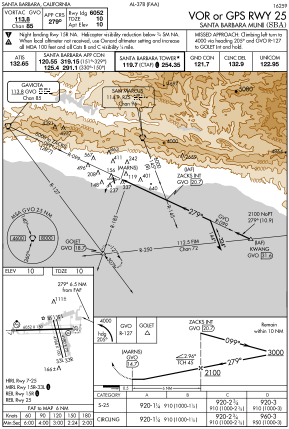
It’s also important for the controller to understand what the pilot will do once he begins the approach. For this procedure, if the pilot begins at GVO, he’ll depart GVO on the 099 radial and maintain 6000 (or descend to 6000 at his discretion if at a higher altitude). After ZACKS intersection (identified by either the GVO 20.7 DME, or the RZS R-145), the pilot can descend at his discretion to 3000. He must complete a course reversal on the south side of the GVO R-099 while remaining within 10 miles of ZACKS intersection. Once he’s established inbound back toward ZACKS, he can descend at his discretion to 2100’. After ZACKS, he can descend to 920’ at his discretion. Once he sees the runway, he can maneuver to line up with the runway and further descend at his discretion. If the pilot doesn’t see the runway by the missed approach point (defined on the chart as GVO 14.7 DME), he will execute a missed approach. As a controller you always need to know the missed approach procedure, because an instrument approach clearance is also a clearance to fly a missed approach.
Vectoring to final for a non-precision approach is very similar to an ILS. The only difference is that, since there’s no glideslope to vector below as with an ILS, the .65 requires that you vector so that they intercept “at an altitude which will allow descent in accordance with the published procedure.” As discussed previously, the 300’ per mile rule still works here for figuring out an appropriate altitude for the intercept.
Since this approach is mostly out over the Pacific Ocean, there are no MVA concerns when vectoring to final (there is high terrain and high MVAs in the area, just not near the final approach course). The MVA south of the final approach course is 1900’. Since the charted final approach fix altitude is 2100’, we should vector to final no lower than 2100’. In this case, the phraseology would be:
“N123SX, 5 miles from ZACKS, turn left heading 300, maintain two thousand one hundred until established on the final approach course, cleared V-O-R runway two five approach.”
Because of the high terrain in the area, you might have an aircraft still descending toward 2100 when you’re turning him to intercept. That’s ok, just make sure that his actual altitude complies with the 300’ per mile rule. So if he will intercept final 10 miles from ZACKS, he can be as high as 5100’ MSL (2100’ FAF altitude plus 300’ times 10 miles) at the point of intercept.